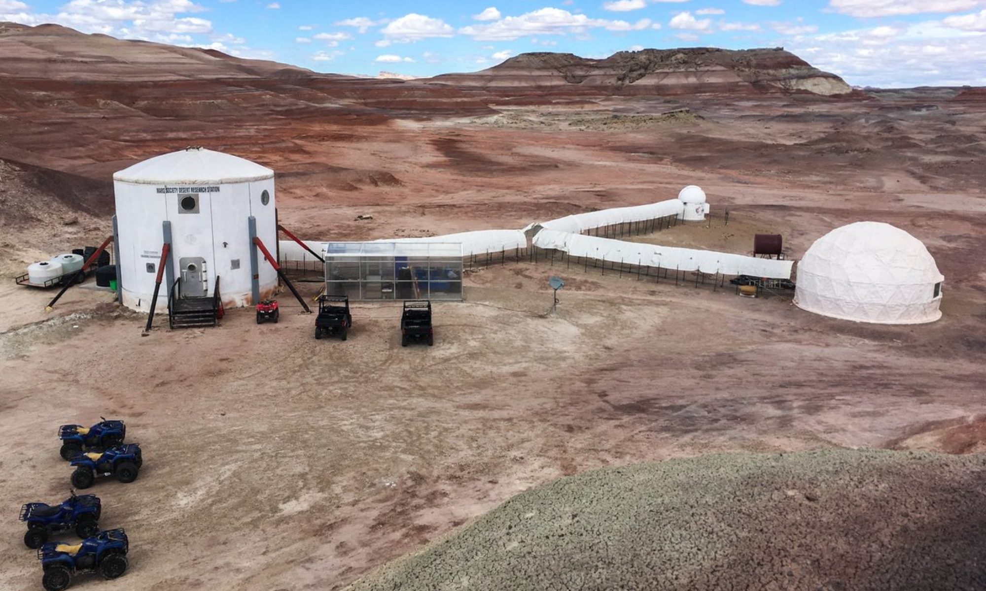

EVA Report – April 7th

Report title: EVA Report
Crew #: 333
Position: Journalist
Report prepared by: Joanna Galloway
Date: 07-04-26
Sol: 9
EVA #:13

Purpose of EVA: Antoine will conduct an (EVA) to carry out his field experiment. The entire crew will participate in two EVA so that he can clearly explain how to observe the landscape and complete the questionnaire consistently. Weather conditions are favorable for drone operations, allowing it to capture the images required for the experiment. In the meantime, all participating crew members will analyze the surrounding landscape according to the defined criteria.
Start time: 9.06 am
End time: 11.47 am
Narrative: after a few issues with the microphones, the crew was able to start decompression at 9.06am. In spirit there was Matthias and Zahraa and in Curiosity there was Antoine and Marie. They left at 9.15am in direction for Green Mars View. at 9.42am at green mars view still have enough battery in the Rovers and are going to do Antoine’s experiences. They explored the terrain which at first wasn’t too interesting for his experience but then after a bit of walking, he found the perfect place. At 11.08am, They finished the experiment and made their way back home by 11.42am
Destination per MDRS Map: Green Mars View
Destination Coordinates (use UTM WGS 84): 0520599E 4256789N
EVA Participants:
Team leader: Antoine, Executive Officer
Matthias, Green Hab Officer
Marie, Commander
Zahraa, HSO
Road(s) and routes per MDRS Map: Cow dung road
Mode of travel: walking and driving (550m from rovers (~0.35 mile))

EVA Report – April 8th

Report title: EVA Report
Crew #: 333
Position: GreenHab Officer
Report prepared by: Matthias De Groote
Date: 08-04-26
Sol: 10

EVA #:15
Antoine will conduct an EVA to carry out his field experiment, all participating crew members will analyze the surrounding landscape according to the defined criteria. Also, Matias will test the radio communication for his experiment in two long range locations. We will check the battery before heading to the Special Region.
Start time: 9.01 am
End time: 11:47 am
Narrative: Crew departed smoothly at 9:10 am with Perseverance and Curiosity. Communication was made at 9:29 am near Special Region. Last communication was made near Green Mars View at 9:44 am, they parked the rovers and continued on foot. They headed back and arrived at Special region at 10:58 am to briefly explore their surroundings. Crew started heading back to the station at 11:23 am. They got back to the station safely at 11:40 am. Decompression started at 11:42 am.
Destination per MDRS Map: Green Mars View & Special Region
Destination Coordinates (use UTM WGS 84): 0520599E 4256789N & 0518165E 4255966N
EVA Participants:
Antoine, Executive Officer -> EVA Leader
Joanna, Journalist
Matias, Astronomer
Road(s) and routes per MDRS Map: Cow dung road
Mode of travel: walking and driving
Vehicles you will be using (If applicable): Spirit & Curiosity

EVA Report – April 9th

Report title: EVA Report
Crew #: 333
Position: Astronomer
Report prepared by: Matias Ballivian Ascarrunz
Date: 09-04-2026
Sol: 11

EVA #: 17
Purpose of EVA: Joanna will take a part of the crew members to collect data for her experiment with the heavy gear. After the EVA team will explore the zone in a radius of no more than 1,5 km from the initial point, so that Antoine can also conduct his experiment. When they will be back at the station, for a video they will need to take some drone images of the MDRS for our website and social media.
Start time: 9:05 AM
End time: 11: 40AM
Narrative:
They started preparation at 8:45 AM, they started the decompression at 9:05 AM, got in the rovers (9:15 AM ) and started their way to the destination, where they arrived at 9:21 AM. Then, they did Joanna’s experiment, they explored for a little bit and headed back to the rovers at ( 11:14 AM). Arriving to the station at 11:20 AM. Where they took drone footage and started decompression at 11:35 AM.
The rover distribution is the following:
Spirit: Marie & Jo
Curiosity: Antoine & Matthias
Destination per MDRS Map: Camel Kissing Ridge
Destination Coordinates (use UTM WGS 84): 0518279E 4249438N
EVA Participants:
Joanna, Journalist -> EVA Leader
Antoine, Executive officer/Engineer
Marie, Commander
Matthias, Greenhab Officer
Road(s) and routes per MDRS Map: Cow Dung Road
Mode of travel: walking & driving

EVA Report – April 20th

Report title: EVA Report
Crew #: 335
Position: Crew Artist
Report prepared by: Elisa Strinna
Date: 19-04-2026
Sol: 1
EVA #: 1
Purpose of EVA:Practice EVA and look around for desiccated soil samples and for film making
Start time: 10:00
End time: 10:52
Narrative: We started preparation at 8:39 AM, we started the decompression at 8:55 AM, got in the rovers (9:00 AM ) and started our way to the destination. We arrived at 9:10 AM. We explored the area on the right side of the road for a little bit, took some pictures and short videos, and headed back at 10.38 AM. We arrived to the station at 11.46 AM. We started decompression and entered the hub at 11.52
Destination per MDRS Map: Marble Ritual
Destination Coordinates (use UTM WGS 84): 4250800N, 518750W
EVA Participants: Matteo Calore and Elisa Strinna
Road(s) and routes per MDRS Map: The EVA will begin on Moonwalk Road, then proceed along Cow Dung Road 0110 to Marble Ritual.
Mode of travel: Spirt

EVA Report – April 20th

Crew #: 335

Position: Crew commander

Report prepared by: Dave Laude

Date: 20-04-2026

Sol: 1

EVA #: 3

Narrative:

The purpose of this EVA was to survey much ground along travel route for film makers to consider for filming during the EVA or a later return. We will stop along the route as needed for filming. Also, for commander’s panaramic photo survey.

The EVA began at 1:30 PM heading north on Co Dung Rd. heading to final destination of Green Mars overlook, but Perseverance, with two passengers and heavy professional video camera and super duty tripod, charge dropped to 50% at Brahe Highway intersection. We decided too far to continue so turned around. During the trip there were four excellent filming stops thus making good use of the 3 hours. Returned at 4:30 PM. Dave’s panoramic photo project accomplished half of intended goals due to turning back. It will be reviewed to see if successful or if changes needed.
Destination : Green Mars View

Coordinates (use UTM WSG 84) :

Green Mars View : 4257000N, 520500W

EVA Participants:

Dave Laude (Commander)

Matteo Calore (HSO/Journalist)

Elisa Strinna (Artist)

Road(s) and routes per MDRS Map: The crew departed the MDRS via Moonwalk Road, then follow Cow Dung Road to Brahe Highway intersection

Mode of travel: driving

EVA Report – April 20th

Report title: EVA Report

Crew #: 335

Position: greenhab officer

Report prepared by: Charlotte Brugge

Date: (20-04-2026)

Sol: Day 1

EVA #: 2

Purpose of EVA: Marble ritual

Start time: 10.30

End time: 11.50

Narrative: we did decompression at 10.30, drove out to Marble ritual to walk and climb up a bit to look at the station. Dave took some pictures

Destination per MDRS Map:

Destination Coordinates (use UTM WGS 84): 4250800N, 518750W

EVA Participants: David Laude + Lot Brugge

Road(s) and routes per MDRS Map: The EVA will begin on Moonwalk Road, then proceed along Cow Dung Road 0110 to Marble Ritual.

Mode of travel: Rover + walk

EVA Report – April 21st

Report title: EVA Report

Crew #: 335

Position: Engineer

Report prepared by: Katherine Berry

Date: 21-Apr-2026

Sol: 2

EVA #: 4

Purpose of EVA: The objective of this EVA was to evaluate the operational differences between piloting a drone with and without the EVA suit. Participants will first operate the drone from inside the observation deck without an EVA suit, and then repeat the operation from outside the fence while wearing the required protective equipment.

Start time: 10:00

End time: 10:30

Narrative: The EVA team proceeded on foot to the Solar Observatory observation deck as planned. Due to time constraints and prioritization of initial testing, operations were conducted from the observation deck without EVA suits. The team performed two controlled drone flight circuits to simulate baseline conditions for the study, focusing on maneuverability and controller handling without the limitations imposed by an EVA suit. Environmental conditions were stable, low wind and allowed for clear visibility and safe operation.

The session was cut short when the drone controller battery reached a critically low level (17%) preventing continuation of the planned comparative trials outside the fence line with full EVA gear.

The study will be postponed and rescheduled for a future EVA, contingent on suitable weather conditions and full equipment readiness.

Destination per MDRS Map: Solar Observatory

Destination Coordinates : 38.41N 110.79W

EVA Participants: Kat Berry,David Laude

Road(s) and routes per MDRS Map: N/A

Mode of travel: Walking

EVA Report – April 21st

Report title: EVA Report

Crew #: 335

Position: GreenHab officer

Report prepared by: Lot Brugge

Date: 21-Apr-2026

Sol: Day 2

EVA #5

Purpose of EVA: To collect clay

Start time: 14.06

End time: 16.20

Narrative: We started decompression at 14:01 and then drove out to Brahe. Lot began digging and collecting samples near the road. Later, the team moved up the hill to gather additional samples and conducted a coil test.

Afterward, they descended back to the initial site to collect possible blue and red clay. Further tests were carried out by adding water and observing how the clay reacted. Matteo documented the process on video, while Elisa handled audio recording. Dave provided guidance and took photographs throughout.

We then headed to the area between North Ridge and Cow Dung Road, where we walked around and collected more clay samples before driving back.

Destination per MDRS Map: Brahe Road + at the area of north ridge

Destination Coordinates (use UTM WGS 84): N5186500,W425180, N5177550,W425480

EVA Participants: David Laude + Lot Brugge + Elisa Strinna + Matteo Calore

Road(s) and routes per MDRS Map: Cow Dung Road

Mode of travel: Rover + Walking

EVA Report – April 23rd

Report title: EVA Report

Crew #: 335

Position: Engineer

Report prepared by: Katherine Berry

Date: 23Apr2026

Sol: 4

EVA #: 6

Purpose of EVA: The objective of this EVA is to refine and complete evaluation of operational differences in drone piloting with and without an EVA suit. Participants will reestablish baseline control from the observation deck without a suit, followed by replicated operations outside the fence while in full protective equipment.

Start time: 9:30

End time: 10:00

Narrative: Crewmates departed the Hab at 09:30 and proceeded on foot toward the Solar Observatory as planned. Upon arrival, the team completed several operational circuits using the drone system from the observation deck where no EVA gear was needed.

As operations progressed, wind conditions began to increase, gradually impacting both drone stability and operator comfort.

Due to the continued rise in wind intensity, the EVA was concluded early. The team safely returned and secured all equipment without issue. Remaining test objectives will be rescheduled and completed during a future EVA under more favorable environmental conditions.

Destination per MDRS Map: Solar Observatory

Destination Coordinates : 38.41N 110.79W

EVA Participants: Kat Berry,David Laude

Road(s) and routes per MDRS Map: N/A

Mode of travel: Walking

EVA Report – April 23rd

Report title: EVA Report

Crew #: 335

Position: GreenHab officer

Report prepared by: Charlotte Brugge

Date: 23APR2026

Sol: Day 4

EVA #7

Purpose of EVA: To collect clay

Start time: 14.30

End time: 16.50

Narrative: The EVA began later than planned due to technical issues with equipment brought by the film crew. This caused a delay in departure and required some troubleshooting before we were able to proceed safely. Additionally, we encountered an issue with the rover Curiosity, which showed a rapidly declining battery level while reading the SOC at rest (see op report). To avoid risk, we switched to the rover Spirit, which performed reliably for the remainder of the EVA.

Despite the delayed start, the journey was highly enjoyable. We traveled toward Candor Chasm, taking time to appreciate the landscape along the route. Upon arrival, the team made multiple stops to explore the area more closely. Three of the crew descended into the chasm, while the commander remained a little further back at the chasm entrance near the rovers to maintain consistent communication with HabCom and the crew.

During exploration, the team identified a deposit of black clay, which appeared scientifically interesting. A large sample was collected and transported back using a bucket, though carrying it proved physically demanding. On the return journey, we made several additional stops to gather more clay samples from different locations to ensure a broader collection.

Overall, morale remained high throughout the EVA. The combination of productive scientific and creative work, smooth rover operations after the switch, and the striking environment contributed to a very positive and enjoyable experience for the entire team.

Destination per MDRS Map: Candour Chasma, and we stopped along Galileo and Cow Dung Rd.

Destination Coordinates (use UTM WGS 84): 0521772E 4250977N

EVA Participants: David Laude + Lot Brugge + Elisa Strinna + Matteo Calore

Road(s) and routes per MDRS Map: Cow Dung Road + Galileo Road

Mode of travel: Rover + Walking

Copyright © The Mars Society. All rights reserved. | Main Site