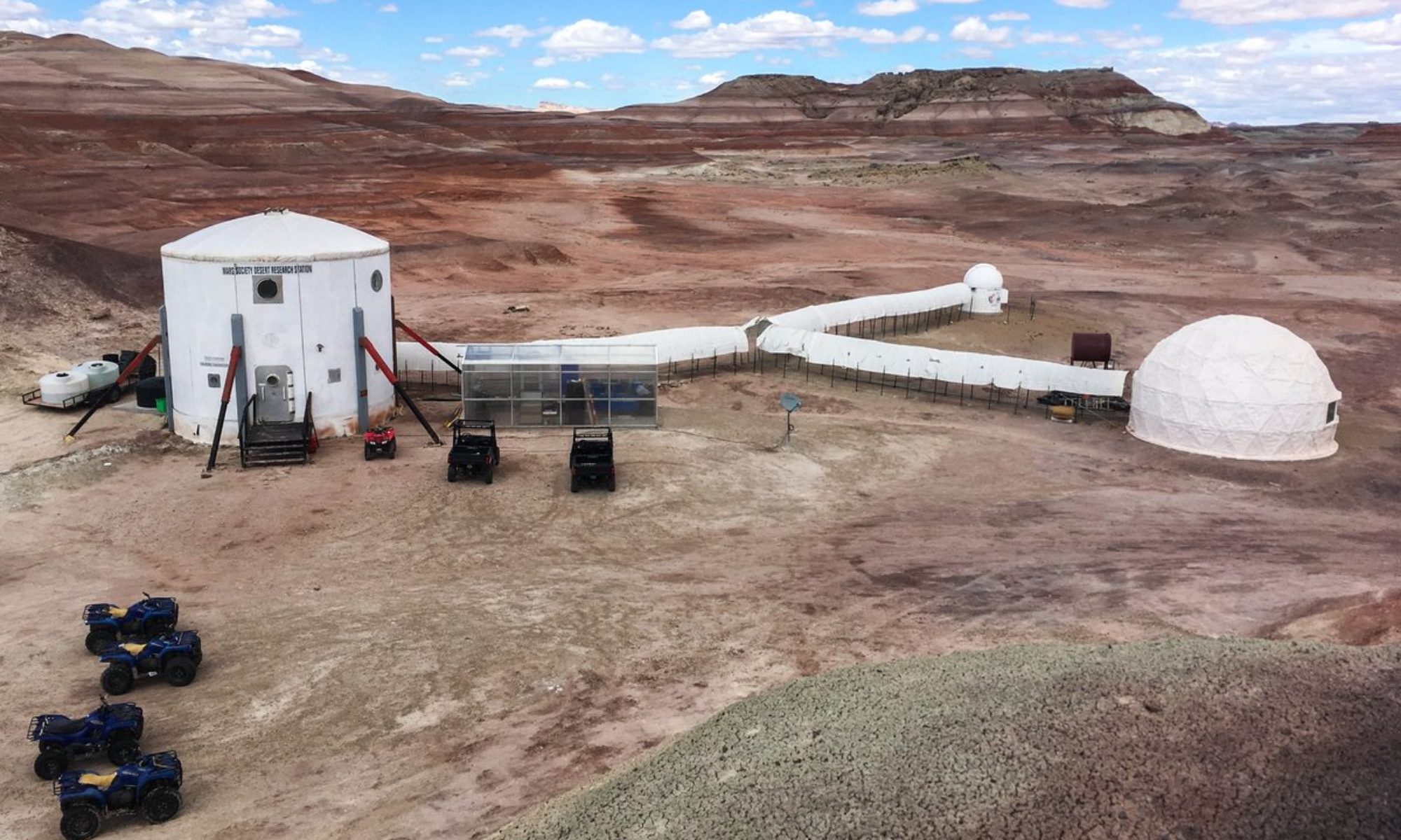

EVA Report – March 30th

Report title: EVA Report
Crew #: 333
Position: Executive Officer / Crew Engineer
Report prepared by: Antoine Dubois
Date: 30-03-2026
Sol: 1

EVA #: 2

Purpose of EVA: We are heading out to scout the area and check that all the equipment is functional in the field.

Start time: 2:05 p.m.
End time: 3:37 p.m.

Narrative:
At 2:05 PM, the crew completed decompression and boarded the rovers Perseverance and Spirit, marking the beginning of the EVA. The first stop was Pooh’s Corner, where the team familiarize themselves with the terrain and conducted initial communication tests between the station and the EVA crew.

At 2:36 PM, the crew returned to the rover and departed for the second stop. A minor GPS issue arose during transit but was quickly identified and successfully resolved, allowing the mission to proceed without delay. Upon arrival at Cowboy Corner, the team explored the area and initiated a search for potential fossils, taking time to observe the geological features of the site.

At 3:19 PM, the crew left Cowboy Corner and headed back to the station, arriving at 3:29 PM. Decompression procedures began at 3:32 PM and were successfully completed at 3:37 PM, marking the end of the EVA.

Destination per MDRS Map: Pooh’s Corner and Cowboy Corner

Destination Coordinates (use UTM WGS 84): E 577700, N 4254200 (Zone 12N); E 519981, N 4252143 (Zone 12N)

EVA Participants:
Matthias De Groote, Greenhab Officer (Team Lead)
Matias Ballivian, Astronomer
Zahraa Al-Bayati, HSO

Road(s) and routes per MDRS Map: Cow dung Road to the North

Mode of travel: Driving and walking

EVA Report – March 30th

Report title: EVA Report
Crew #: 333
Position: Astronomer
Report prepared by: Matias Ballivian Ascarrunz
Date: 30-03-2026
Sol: 1

EVA #: 1

Purpose of EVA: We are heading out to scout the area and check that all the equipment is functional in the field.

Start time: 9:00 AM
End time: 11:00 AM

Narrative: We performed a dry test of the EVA equipment, the EVA comms kit #2 had the headset not working we replaced it with the one from the kit #4. The rest of the equipment was working just fine. The EVA team performed 5 min of decompression and did the check of the rover and state of battery. The team moved to Pooh’s corner to try the drone and assured the good function of it, then they went to the cowboy corner with the rover and explored the area by foot. After sometime they came back/, with no further news.

Destination per MDRS Map: Pooh’s Corner and Cowboy Corner
Destination Coordinates (use UTM WGS 84): E 577700, N 4254200 (Zone 12N); E 519981, N 4252143 (Zone 12N)

EVA Participants:
Marie, Commander, Team Lead
Antoine, Executive officer
Joanna, Journalist

Road(s) and routes per MDRS Map: Cow dung Road to the North

Mode of travel: Driving and walking

EVA Report – March 31st

Report title: EVA Report
Crew #: 333
Position: Astronomer
Report prepared by: Matias Ballivian Ascarrunz
Date: 31-3-2026
Sol: 2

EVA #: 3

Purpose of EVA: An outing for Antoine’s research. The goal is to observe the landscape from an astronaut’s perspective and then capture video footage and photos with the drone.

Start time: 9:00 AM
End time: 10:56 AM

Narrative: The team prepared their equipment for the EVA at 8:30 AM, after confirming everything was working smoothly, the headset of comms kit #2 was not repaired. They departed at 9:00 AM after the decompression, they took Opportunity and Curiosity rovers. They arrive at Compass Rock with no further problem at 9:30AM to start with the research from Antoine. After accessing the terrain by walking to a higher view point where one of the crew members had a small fall, they walked a little further than the rovers to start answering Antoine’s questionnaire. The team realised that Antoine forgot to take one of the drone cables but this wasn’t much of an issue as he is planned to go out later today in the afternoon. They answered the first part of the questionnaire then returned to their rovers. They came back to the Hab without issue at 10:49am and put their rovers to charge. They started decompression at 10:51 am with no issues.

Destination per MDRS Map: Compass Rock
Destination Coordinates (use UTM WGS 84): 519900E 4263000N

EVA Participants:
Antoine, Executive officer (Team lead)
Joanna, Journalist
Matthias, Greenhab Officer

Road(s) and routes per MDRS Map: Cow Dung road and Galileo road
Mode of travel: Driving and walking

EVA Report – March 31st

Report title: EVA Report
Crew #: 333
Position: Journalist
Report prepared by: Joanna Galloway
Date: 31-3-2026
Sol: 2

EVA #: 4

Purpose of EVA: An outing for Antoine’s research. The goal is to observe the landscape from an astronaut’s perspective and then capture video footage and photos with the drone.

Start time: 01:56 PM
End time: 4:06 PM

Narrative: Started decompression at 01:56 PM, The Crew unplugged Curiosity and Opportunity which charged over lunch time and took Perseverance and Spirit towards Compass Rock, departing from the MDRS at 2:04 PM, they arrived at Campus Rock at 2:15PM. There Antoine flew the drone to take some pictures and videos for his research, then he made the team complete a form. At around 2:48 pm the door to the station swung open because of the high wind force, the crew made its way back to the station to shut it and drove back to Campus Rock around 3:06pm.

They arrived back to the terrain at 3:17 pm to continue Antoine’s experience. Where they walked toward the recorded site to better understand the terrain. Then, they returned to their rovers at 3:55pm and arrived back at the station at 4:06pm. Decomp started at 16:07pm back

Destination per MDRS Map: Compass Rock
Destination Coordinates (use UTM WGS 84): 519900E 4263000N

EVA Participants:
Antoine, Executive officer (Team lead)
Marie, Commander
Matias, Astronomer

Road(s) and routes per MDRS Map: Cow Dung road and Galileo road

Mode of travel: Driving and walking

EVA Report – April 2nd

Report title: EVA Report
Crew #: 333
Position: Astronomer
Report prepared by: Matias Ballivian Ascarrunz
Date: 02-04-2026
Sol:4

EVA #: 6

Purpose of EVA: We are heading out there to explore the area and find the right spot for Joanna’s experiment.

Start time:08:12 AM
End time: 10:05 AM

Narrative: The crew started to prepare for the EVA at 07:40 AM after breakfast. After a check we discovered that comms kit #4 Headset was causing static noise. Everything else was working fine. They started decompression at 08:05 AM and then went to the rover and started their way to the Special Region. At Cowboy Corner we did a radio test for Matias’ experiment, then also at the Special Region where they arrived at 08:45. They continued their EVA walking. At 09:33 AM they returned to the rovers, to go back to the station. They arrived at 09:54 AM. Where they filmed a little video and then started decompression at 10:00 AM.

Destination per MDRS Map: Special Region
Destination Coordinates (use UTM WGS 84): 518500E, 4256000N

EVA Participants:
Matthias, Greenhab Officer (Team lead)
Antoine, executive officer
Marie, commander

Road(s) and routes per MDRS Map: Cow Dung road and Gateway to Lith

Mode of travel: walking and driving

EVA Report – April 3rd

Report title: EVA Report
Crew #: 333
Position: HSO
Report prepared by: Al-bayati Zahraa
Date: 03-04-2026
Sol: 5

EVA #: 7

Purpose of EVA: Antoine will conduct an EVA to carry out his field experiment. If conditions permit, a drone will be deployed to capture the images needed for the experiment. If not, the task will be postponed and carried out during a future EVA with other crew members. In the meantime, all participating crew members will analyze the surrounding landscape according to the defined criteria.

Start time: 9:03
End time: 11:37

Narrative: Preparations began at 8:30 AM with the EVA officially starting at 9:03 AM following a radio check. Communication was one-sided throughout: transmissions from the EVA crew were clear, but CapCom-to-crew reception was frequently poor.

The crew traveled along Cow Dung Road, making stops along Brahe Highway 157-2 and at the Overlook, where Antoine’s experiment was conducted due to battery concerns limiting further vehicle travel. An additional stop was made on Cow Dung Road for Matìas’s experiment, during which GPS coordinates were recorded multiple times by the CapCom.

The crew returned to the station at 11:32 AM, reported rover parameters, and completed the standard 5-minute airlock decompression sequence, concluding the EVA.

Destination per MDRS Map: sea of shells
Destination Coordinates (use UTM WGS 84): 4255500N 516500W

EVA Participants:
Antoine, Executive Officer (Team lead)
Matias, Astronomer
Joanna, Journalist

Road(s) and routes per MDRS Map: Cow Dung Road then Brahe Hwy then Copernicus Hwy
Mode of travel: driving and walking

Rovers: Spirit, Perseverance

EVA Report – April 3rd

Report title: EVA Report
Crew #: 333
Position: Astronomer
Report prepared by: Matias Ballivian Ascarrunz
Date: 03-04-2026
Sol: 5

EVA #: 8

Purpose of EVA: The team went to Antoine’s experiment site to conduct the experiment. Antoine explained his experiment before the EVA. All participating crew members will analyze the surrounding landscape according to the defined criteria.

Start time: 2:06 p.m.
End time: 3:49 p.m.

Narrative: Preparations began at 1:30 PM with the EVA officially starting at 2:06 PM following a radio check. Communication was one-sided throughout: transmissions from the EVA crew were clear, but CapCom-to-crew reception was frequently poor. The crew traveled along Cow Dung Road to the destination they arrived with no further news. They started completing the document for Antoine’s research. They finished at 2:44 PM, so they went exploring to Sea of Shells. They drove carefully because the roads were difficult.

The team climbed a hill to have better visibility. They got back into their rovers and headed back. The crew returned to the station, reported rover parameters, and completed the standard 5-minute airlock decompression sequence, concluding the EVA.

Destination per MDRS Map: Sea of Shells
Destination Coordinates (use UTM WGS 84): 4255500N 516500W

EVA Participants:
Marie, Commander (Team lead)
Zaharaa, HSO
Matthias, Greenhab Officer

Road(s) and routes per MDRS Map: Cow Dung Road then Brahe Hwy then Copernicus Hwy
Mode of travel: driving and walking

Rovers: Opportunity & Curiosity

EVA Report – April 4th

Report title: EVA Report
Crew #: 333
Position: Astronomer
Report prepared by: Matias Ballivian Ascarrunz
Date: 04-04-2026
Sol: 6

EVA #: 9

Purpose of EVA: Joanna will conduct this EVA to find the terrain to carry out her experiment next week. Antoine will also make the most of this time and see if the terrain corresponds to his need for a further experiment next week. In the meantime, Marie will give the needed feedback on the terrain for both experiments.

Start time: 8:38 AM
End time: 12:22 PM

Narrative: They started decompression at 8:33 AM, went to their rover and started the way to Somerville Overview. Crew arrived at 9:56 AM to Compass Rock where they didn’t find the correct route directly. They corrected the course and arrived at Somerville Overview at 10:10 AM. Where they explore the zone and take photos for the analysis of the terrain for their experiences. After exploring for a bit they went back to their rovers and got back to the station at 12:15 PM and decompressed before getting back in the HAB.

Destination per MDRS Map: Somerville Overview (and if enough time Watney road)
Destination Coordinates (use UTM WGS 84): 522000E, 4253000N (and 520000E, 4250500N)

EVA Participants:
Joanna, Journalist (Team lead)
Marie, Commander
Antoine, Executive Officer

Road(s) and routes per MDRS Map: Cow Dung road, Galileo road (and Watney road)

Mode of travel: Walking & driving

EVA Report – April 4th

Report title: EVA Report
Crew #: 333
Position: Commander
Report prepared by: Marie Jansen
Date: 04-04-2026
Sol: 6

EVA #: 10

Purpose of EVA:
For Matias’ experiment we will go to the North ridge repeater to see the difference in reception of the different channels (#1 and #2). Then we will go to the Kissing Camel Ridge West, to compare the difference in reception compared to the North ridge, because they are at a similar distance from the HAB.

Start time: 2:00 PM
End time: 04:20 PM

Narrative: They started decompression at 1:55 PM, They headed out on foot towards North Ridge. They arrived at 2:35 PM. They explored the area and found ways to communicate with us on both channels. They left North Ridge at 3:07 PM. They then headed towards Kissing Camel Ridge West (KCRW), but they confused the ridge with another so they arrived 500m north from KCRW. They departed from there at 4:07 PM. and arrived at the station back at 4:25 PM.

Destination per MDRS Map: North Ridge, Kissing Camel Ridge West

Destination Coordinates (use UTM WGS 84): 0518491E 4251750N; 0517819E 4249635N

EVA Participants:
Matias, Astronomer (Team lead)
Antoine, Executive Officer

Road(s) and routes per MDRS Map: Road 1103 and Hab Ridge Road

Mode of travel: Walking

EVA Report – April 6th

Report title: EVA Report
Crew #: 333
Position: Crew Executive Officer / Crew Engineer
Report prepared by: Antoine Dubois
Date: 06-04-2026
Sol: 8

EVA #: 11
Purpose of EVA: This time, Joanna will conduct her experiment outdoors with the entire crew. They will head to Cowboy Corner to take advantage of the outdoor setting, without straying too far from the MDRS. The crew will use the Tap Strap to perform the various tasks necessary for the success of Joanna’s experiment.
Start time: 9:05 AM
End time: 10:51 AM
Narrative:
The purpose of this EVA was to support Joanna’s experiment, conducted outdoors with the participation of the entire crew. The team selected Cowboy Corner as the study site, allowing for a suitable field environment while remaining within a safe distance from the MDRS. The crew used the Tap Strap to perform the various tasks required for the success of the experiment.
A minor technical issue occurred prior to departure, requiring a rover reassignment due to a charging problem. The final crew distribution was as follows: Opportunity with Marie and Joanna, and Spirit with Matthias and Zahraa. Once resolved, the crew proceeded to the field without further delay.
The team arrived at Cowboy Corner at 9:25 AM, and the experiment began shortly after at 9:30 AM. All planned tasks were successfully completed by 10:00 AM. Following the experiment, the crew conducted a short on-foot exploration of the surrounding area starting at 10:10 AM, taking advantage of the location to observe the terrain.
The crew departed the site at 10:43 AM and returned to the station at 10:49 AM. Decompression procedures began at 10:51 AM, marking the end of the EVA.
Destination per MDRS Map: Cowboy Corner
Destination Coordinates (use UTM WGS 84): E 519981, N 4252143 (Zone 12N)
EVA Participants:
Team leader: Joanna Galloway, Crew Journalist
Marie Jansen, Commander
Zahraa Al-bayati, HSO
Matthias De Groote, Greenhab Officer
Road(s) and routes per MDRS Map: Cow dung Road to the North
Mode of travel: Driving and walking (0.2miles away from the Rovers)

Copyright © The Mars Society. All rights reserved. | Main Site